การเปรียบเทียบประสิทธิภาพสถาปัตยกรรม CNN ร่วมกับเทคนิคการเสริมข้อมูลสำหรับการจำแนกประเภทการใช้ประโยชน์ที่ดินจากภาพถ่ายดาวเทียม Sentinel-2
DOI:
https://doi.org/10.14456/jcct.2025.8คำสำคัญ:
การจำแนกประเภทการใช้ประโยชน์ที่ดิน, การเรียนรู้เชิงลึก, ภาพถ่ายดาวเทียม, การเสริมข้อมูลบทคัดย่อ
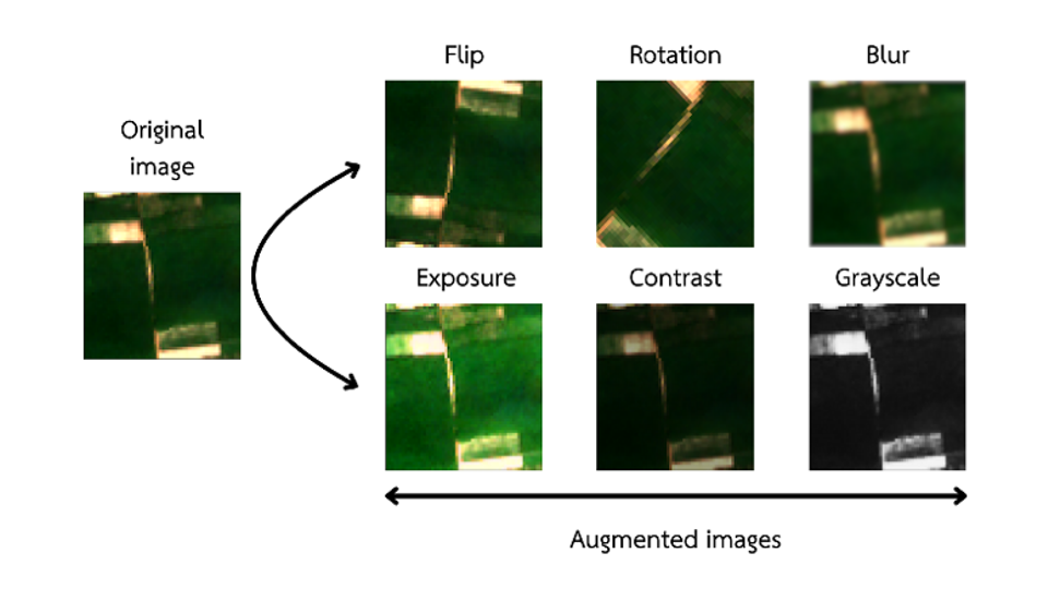
การจำแนกประเภทการใช้ประโยชน์ที่ดินมีบทบาทสำคัญในการจัดการทรัพยากรธรรมชาติและการวางผังเมือง โดยให้ข้อมูลที่จำเป็นสำหรับการประเมินการเปลี่ยนแปลงเชิงพื้นที่และผลกระทบต่อระบบนิเวศ วัตถุประสงค์ของงานวิจัยเพื่อสร้างและวิเคราะห์ประสิทธิภาพของสถาปัตยกรรมโครงข่ายประสาทเทียมแบบคอนโวลชัน (CNNs) สามรูปแบบ ได้แก่ ResNet50V2, DenseNet121 และ EfficientNetV2B0 ในการจำแนกประเภทการใช้ประโยชน์ที่ดินจากภาพถ่ายดาวเทียม Sentinel-2 งานวิจัยนี้ได้ประยุกต์ใช้เทคนิคการเสริมข้อมูล เพื่อแก้ไขปัญหาความไม่สมดุลของชุดข้อมูลและลดปัญหาการเรียนรู้เกิน พื้นที่ศึกษาในตำบลสายตะกูได้รับการจำแนกออกเป็นห้าประเภทการใช้ประโยชน์ที่ดิน ผลการวิเคราะห์แสดงให้เห็นว่า ResNet50V2 มีประสิทธิภาพสูงสุด โดยให้ค่าความถูกต้อง ร้อยละ 88 เมื่อใช้ร่วมกับเทคนิคการเสริมข้อมูลในขณะที่ DenseNet121 แสดงประสิทธิภาพปานกลางที่ร้อยละ 77 และ EfficientNetV2B0 แสดงประสิทธิภาพต่ำกว่าที่ร้อยละ 47 ผลการศึกษานี้บ่งชี้ว่า ResNet50V2 เมื่อประยุกต์ใช้ร่วมกับเทคนิคการเสริมข้อมูลเป็นวิธีการที่มีประสิทธิภาพสูงสุดสำหรับการจำแนกประเภทการใช้ประโยชน์ที่ดิน แสดงให้เห็นถึงศักยภาพในการสนับสนุนการจัดการทรัพยากร และการวางแผนเชิงพื้นที่อย่างมีประสิทธิภาพสำหรับการประยุกต์ใช้ในอนาคต
Downloads
เอกสารอ้างอิง
Alzahem, A., Boulila, W., Koubaa, A., Khan, Z., & Alturki, I. (2023). Improving Satellite Image Classification Accuracy Using GAN-based Data Augmentation and Vision Transformers. Earth Science Informatics, 16(4), 4169–4186. https://doi.org/10.1007/s12145-023-01153-x.
Belgiu, M., & Csillik, O. (2018). Sentinel-2 Cropland Mapping Using Pixel-based and Object-based Time-weighted Dynamic Time Warping Analysis. Remote Sensing of Environment, 204, 509–523. https://doi.org/10.1016/j.rse.2017.10.005.
Dobrinić, D., Medak, D., & Gašparović, M. (2020). Integration of Multitemporal Sentinel-1 and Sentinel-2 Imagery for Land-cover Classification Using Machine Learning Methods. The International Archives of the Photogrammetry, Remote Sensing and Spatial Information Sciences, XLIII-B1-2020, 91–98. https://doi.org/10.5194/isprs-archives-XLIII-B1-2020-91-2020.
Gerdan Koc, D., Koc, C., Polat, H. E., & Koc, A. (2024). Artificial Intelligence-based Camel Face Identification System for Sustainable Livestock Farming. Neural Computing and Applications, 36(6), 3107–3124. https://doi.org/10.1007/s00521-023-09238-w.
Gibson, R., Danaher, T., Hehir, W., & Collins, L. (2020). A Remote Sensing Approach to Mapping Fire Severity in South-eastern Australia Using Sentinel 2 and Random Forest. Remote Sensing of Environment, 240, 111702. https://doi.org/10.1016/j.rse.2020.111702.
Hao, M., Dong, X., Jiang, D., Yu, X., Ding, F., & Zhuo, J. (2024). Land-use classification based on high-resolution remote sensing imagery and deep learning models. PLOS ONE, 19(4), e0300473. https://doi.org/10.1371/journal.pone.0300473.
Khan, M., Hanan, A., Kenzhebay, M., Gazzea, M., & Arghandeh, R. (2024). Transformer-based Land Use and Land Cover Classification with Explainability Using Satellite Imagery. Scientific Reports, 14(1), 16744. https://doi.org/10.1038/s41598-024-67186-4.
Kussul, N., Lavreniuk, M., Skakun, S., & Shelestov, A. (2017). Deep Learning Classification of Land Cover and Crop Types Using Remote Sensing Data. IEEE Geoscience and Remote Sensing Letters, 14(5), 778–782. https://doi.org/10.1109/LGRS.2017.2681128.
Liang, J., Deng, Y., & Zeng, D. (2020). A Deep Neural Network Combined CNN and GCN for Remote Sensing Scene Classification. IEEE Journal of Selected Topics in Applied Earth Observations and Remote Sensing, 13, 4325–4338. https://doi.org/10.1109/JSTARS.2020.3011333.
Llodrà-Llabrés, J., Martínez-López, J., Postma, T., Pérez-Martínez, C., & Alcaraz-Segura, D. (2023). Retrieving water chlorophyll-a concentration in inland waters from Sentinel-2 imagery: Review of operability, performance and ways forward. International Journal of Applied Earth Observation and Geoinformation, 125, 103605. https://doi.org/10.1016/j.jag.2023.103605
Lu, L., Wang, L., Yang, Q., Zhao, P., Du, Y., Xiao, F., & Ling, F. (2023). Extracting a Connected River Network from DEM by Incorporating Surface River Occurrence Data and Sentinel-2 Imagery in the Danjiangkou Reservoir Area. Remote Sensing, 15(4), 1014. https://doi.org/10.3390/rs15041014.
Mahakalanda, I., Demotte, P., Perera, I., Meedeniya, D., Wijesuriya, W., & Rodrigo, L. (2022). Deep Learning-based Prediction for Stand Age and Land Utilization of Rubber Plantation. In Khan, M. A., Khan, R., & Ansari, M. A. (Eds), Application of Machine Learning in Agriculture (131–156). Elsevier. https://doi.org/10.1016/B978-0-323-90550-3.00008-4.
Murel, J., & Kavlakoglu, E. (2024). What is Data Augmentation?. IBM. https://www.ibm.com/topics/data-augmentation.
Paramanantham, P. M., & Seenivasan, S. R. (2025). Optimized Deep Learning based Classification and Prediction of Land Use/ Land Cover Changes from Satellite Images. Signal, Image and Video Processing, 19(5), 415. https://doi.org/10.1007/s11760-025-03937-8.
Phiri, D., Simwanda, M., Salekin, S., Nyirenda, V., Murayama, Y., & Ranagalage, M. (2020). Sentinel-2 Data for Land Cover/Use Mapping: A Review. Remote Sensing, 12(14), 2291. https://doi.org/10.3390/rs12142291.
QGIS. (2024). Spatial without Compromise. https://www.qgis.org.
Rozario, P. F., Gadgil, R., Lee, J., Gomes, R., Keller, P., Liu, Y., Sipos, G., McDonnell, G., Impola, W., & Rudolph, J. (2024). Optimizing Mobile Vision Transformers for Land Cover Classification. Applied Sciences, 14(13), 5920. https://doi.org/10.3390/app14135920.
Seydi, S. T., Amani, M., & Ghorbanian, A. (2022). A Dual Attention Convolutional Neural Network for Crop Classification Using Time-Series Sentinel-2 Imagery. Remote Sensing, 14(3), 498. https://doi.org/10.3390/rs14030498.
Shorten, C., & Khoshgoftaar, T. M. (2019). A survey on Image Data Augmentation for Deep Learning. Journal of Big Data, 6(1), 60. https://doi.org/10.1186/s40537-019-0197-0.
Sierra, S., Ramo, R., Padilla, M., & Cobo, A. (2025). Optimizing Deep Neural Networks for High-resolution Land Cover Classification through Data Augmentation. Environmental Monitoring and Assessment, 197(4), 423. https://doi.org/10.1007/s10661-025-13870-5.
Singh, G., Singh, S., Sethi, G., & Sood, V. (2022). Deep Learning in the Mapping of Agricultural Land Use Using Sentinel-2 Satellite Data. Geographies, 2(4), 691–700. https://doi.org/10.3390/geographies2040042.
Sudta, P. (2023). Marketers and AI: Confusion Matrix and Principles for Evaluating ML Models. Everyday Marketing. https://everydaymarketing.co/business-and-marketing-case-study/ai/confusion-matrix-ml-evaluation. (In Thai)
Vali, A., Comai, S., & Matteucci, M. (2020). Deep Learning for Land Use and Land Cover Classification Based on Hyperspectral and Multispectral Earth Observation Data: A Review. Remote Sensing, 12(15), 2495. https://doi.org/10.3390/rs12152495.
Wang, Y., Zhang, Z., Feng, L., Ma, Y., & Du, Q. (2021). A New Attention-based CNN Approach for Crop Mapping Using Time Series Sentinel-2 Images. Computers and Electronics in Agriculture, 184, 106090. https://doi.org/10.1016/j.compag.2021.106090.
Wubineh, B. Z., Rusiecki, A., & Halawa, K. (2024). Classification of Cervical Cells from the Pap Smear Image Using the RES_DCGAN Data Augmentation and ResNet50V2 with Self-attention Architecture. Neural Computing and Applications, 36(34), 21801–21815. https://doi.org/10.1007/s00521-024-10404-x.
Zhang, T., Su, J., Xu, Z., Luo, Y., & Li, J. (2021). Sentinel-2 Satellite Imagery for Urban Land Cover Classification by Optimized Random Forest Classifier. Applied Sciences, 11(2), 543. https://doi.org/10.3390/app11020543.
Zhu, X. X., Tuia, D., Mou, L., Xia, G.-S., Zhang, L., Xu, F., & Fraundorfer, F. (2017). Deep Learning in Remote Sensing: A Comprehensive Review and List of Resources. IEEE Geoscience and Remote Sensing Magazine, 5(4), 8–36. https://doi.org/10.1109/MGRS.2017.2762307.
ดาวน์โหลด
เผยแพร่แล้ว
รูปแบบการอ้างอิง
ฉบับ
ประเภทบทความ
หมวดหมู่
สัญญาอนุญาต
ลิขสิทธิ์ (c) 2025 วารสารคอมพิวเตอร์และเทคโนโลยีสร้างสรรค์

อนุญาตภายใต้เงื่อนไข Creative Commons Attribution-NonCommercial-NoDerivatives 4.0 International License.